Thursday, February 27, 2020

Canal Stones

The Canal Stones stand in Major's Hill Park south of the ruins of Colonel By's house. The plaque on them faces the nearby bushes and most visitors will likely walk on by them without paying them any attention. They may be stones that were part of the original canal structure, though I could not find this out for sure.


CANAL STONES

TO COMMEMORATE LIEUTENANT-COLONEL JOHN BY, R.E.,
BUILDER OF THE RIDEAU CANAL (1826-1832) AND
FOUNDER OF BYTOWN (LATER RENAMED OTTAWA),
THE FEDERAL CAPITAL OF THE DOMINION OF CANADA.

ERECTED BY THE HISTORIC LANDMARKS ASSOCIATION OF CANADA
MAY 1915


LES PIERRES DU CANAL

HOMMAGE RENDU AU LIEUTENANT-COLONEL JOHN BY, INGÉNIEUR
MILITAIRE BRITANNIQUE, CONSTRUCTEUR DU CANAL RIDEAU (1826-1832)
ET FONDATEUR DE BYTOWN (PLUS TARD RENOMMÉE OTTAWA),
CAPITALE FÉDÉRALE DU DOMINION DU CANADA

INSTALLÉES PAR LA HISTORIC LANDMARKS ASSOCIATION OF CANADA
EN MAI 1915


Monday, February 24, 2020

Moose Creek War Memorial

The Moose Creek War Memorial, in Moose Creek, Ontario, stands on the south side of Sabourin Street, west of Valley Street on the east side of the Moose Creek fire station.


DEDIÉ
À LA GLOIRE DE DIEU
ET À LA MEMOIRE DE
L'HOMME ET LA FEMME
QUI ONT SERVI
LEUR PAYS ET QUI
ONT DONNÉ LEUR VIE

JE ME SOUVIENS

WORLD WAR I
1914 — 1918

WORLD WAR II
1939 — 1945

KOREA
1950 — 1953

PEACE KEEPING

DEDICATED
TO THE GLORY OF GOD
AND IN MEMORY OF THE
MEN AND WOMEN WHO
SERVED OUR COUNTRY
AND OF THOSE WHO
PAID THE SUPREME SACRIFICE

LEST WE FORGET


Thursday, February 20, 2020

Glengarry Highland Games 60th Anniversary Plaque

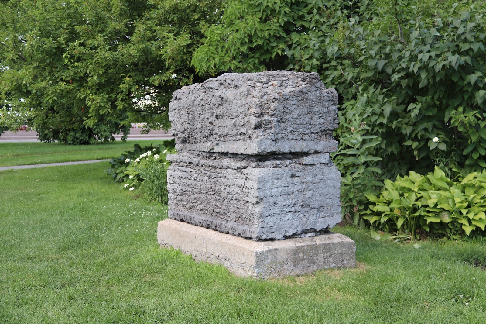
In Maxville Ontario a plaque commemorating the Glengarry Highland Games' 60th Anniversary stands south of the eastern end of Fair Street just inside the Maxville Fair Grounds Gates.


The
Glengarry
Highland Games

"Ceud Mile Failte"
(One Hundred Thousand Welcomes)
Since 1948


Erected on the Occassion of the 60th Anniversary of
the Glengarry Highland Games

On these premises the first Glengarry Highland Games was held on July 31, 1948. Each year since, the best pipe bands on the North American Continent and beyond competed for the North American Pipe Band Championships.

Tribute is paid to all individual competitors in piping, drumming, highland dancing and sports who have contributed to the enjoyment and success of the Games. Recognition and thanks are given to all volunteers, members and directors of the Games; they constitute the heart and sould of the organization.

The Games is also indebted to the many dignitarie from all walks of life who have graced the stage and have helped give the Games the great prestige it has garnered over the years.

Hope is expressed that the remarkable enthusiasm that has been evident by all will continue and the Glengarry Highland Games will prove to be even more successful in the future.

Maxville, Ontario - August, 2007


Monday, February 17, 2020

Hartwells Lockstation

Hartwells Lockstation occupies a location on the Rideau Canal across from and north of the Carleton University Library. The lockstation and paid parking can be accessed from Prince of Wales Drive by Hartwell's Locks Lane.

I have edited the photographs, as much as possible into an order that makes geographic sense. Due to the operation of the locks while photographing them you will see the water level change suddenly as I found it difficult to also edit to a time sequence.


The Government of Canada recognized this store house, built in 1937, at the upstream end of the Hartwells lockstation as a federal heritage building on February 12, 1994.


The Government of Canada recognized this defensible lockmaster's house as a federal heritage building on February 12, 1994. Designed by Royal Engineers the house was built, in 1841, in lieu of a more substantial blockhouse.


This is the weir for the Hartwells Lockstation. A weir is a small dam for controlling the water level. Excess water flows over the control dam through a tunnel and exits at the downstream end of the locks.


HARTWELLS

The canal here is an artifical cut, made to bypass the lower section of the Rideau River. There were originally three locks proposed for Hogs Back, but two were moved to this location to take advantage of topography and lessen the need for excavation.

The lockmasters and their families used to live at the locks, which in the 19th century operated 24 hours a day. The white clapboard of this lockmaster's house hides the fact that the lower storey is constructed of stone. The original building built in the early 1840s, was a one storye stone building, built witht eh defence of the canal in mind. Known as defensible lockmaster's houses, these buildings, with bare stone interiors, were by all accounts not a pleasant place to live. Superintendent Phillips stated, shortly after he was appointed in 1894, "These cottages are all of the same pattern, being square stone structures of one storey only, and although everything has been done to keep the dry that can be suggested, yet they appear to be still damp and unhealthy; ane repairs to them only seem to be a waste of money, as they are over 70 years old." The building was renovated in 1901 with a second storey and interior walls being added to make the building more liveable.

Between 1826 and 1832, an old Indian canoe route along the Rideau and Cataraqui Rivers was transformed at the command of the British government from untamed wilderness rivers into the Rideau Canal. The purpose of this remarkable artery was to provide the British army with a safe route for supplying its inland garrisons, avoiding the direct but exposed route along the St. Lawrence, which only the disorganization of the American forces had prevented from being cut during the War of 1812.

The 202 km (126 miles) of waterway was made navigable by 47 locks grouped in 24 stations with their associatd dams and weirs. The word was designed and superintended by the Royal Engineers, commanded by Lieutenant Colonel John By; the actual construction was done by local contractors.

Despite the blockhouses along the waterway, the role of hte Rideau has always been peaceful. It was a busy waterway, carrying settlers and supplies into the growing settlement of the interior intul the middle of the 19th century, when larger locks were opened on the St. Lawrence. At the same time, since the possibility of war between Britain and the United States was now unlikely, the British Board of Ordnance signed the system over to the colonial government of Canada in 1856. The period of the Canal's military administration was over.

Local commercial traffic remained important until the advent of the automobile and better roads about the time of World War 1. Since that time recreational boating has grown steadily so that now the system, well into its second century, is busier than ever.


HARTWELLS

À cet endroit, la tranchée devait contourner le tronçon inférieur de la rivière Rideau. À l'origine, Hogs Back devait compter trois écluses, mais deux furent aménagées ici pour profiter de la topographie et faciliter les travaux d'excavation.

Les maîtes-éclusiers et leurs familles habitaient aux écluses qui fonctionnaient 24 heures sur 24 au XIXe siècle. Les pierres de l'étage inférieur de cette maison d'éclusier sont cachées par des planches à clin blanches. Le bâtiment d'origine, construit au début des années 1840, comportait un seul étage en pierres et devait servir à la défense du canal. Au dire de tous, il ne faisait pas bon vivre dans ces maisons aux intérieurs en pierres nues. Peu après sa nomination en 1894, le surintendant Phillips décara que ces maisons en pierres, toutes semblables, avaient une structure carrée d'un seul étage, et bien que tout ait été réparer semblait un gaspillage d'argent puisqu'elles avaient plus de 70 ans. Lors des rénovations de 1901, on ajouta un étage ainsi que des murs intérieurs pour rendre le bâtiment plus habitable.

Entre 1826 et 1832, une ancienne voie d'eau utilisée par les Indiens le long des rivières Rideau et Cataraqui fut transformée à la demande du gouvernement britannique en un réseau de voies navagables : le canal Rideau. Le but de cet ouvrage remarquable était de fournir à l'armée britannique une route sûre pour approvisionner ses garnisons. On évitait ainsi le Saint-Laurent, voie plus directe mais oussi plus dangereuse qui n'était demeurée ouverte qu'en raison de la désorganisation de l'armée américaine au cours de la guerre de 1812.

Le réseau de 202 km (126 milles) a été rendu navigable par la construction de 47 écluses regroupées en 24 postes. Les travaux ont été planifiés et surveillés par les Royal Engineers. Sous le commandement du lieutenant-colonel John By. Ils ont été exécutés par des entrepreneurs locaux.

Malgré les blockhaus qui se trouvent le long du réseau, le Rideau n'a jamais été troublé par la guerre. Ce fut un cours d'eau achalandé transportant colons et approvisionnement à l'intérieur des terres jusq'au milieu de XIXe siècle lorsque les grandes écluses du Saint-Laurent furent ouvertes à la navigation. Au même moment, la menace de guerre entre la Grande-Bretagne et les États-Unis s'étant estompée, le British Board of Ordnance céda le réseau au gouvernement colonial du Canada en 1856. Ceal mit fin à l'administration militaire du canal.

Le trafic commercial local demeura important jusqu'à l'apparition de l'automobile et la construction de meilleurs routes à l'époque de la Première Guerre mondiale. Depuis, les plaisanciers se sont faits de plus en plus nombreux, tant et si bien qu le réseau, qui en est à son deuxième siècle d'existence, et maintenant plus fréquenté que jamais.


This is the lower gate for lock 10
and the upper gate for lock 9.


This is the outlet for water flowing over the weir.