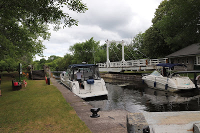
The Upper Nicholsons Lockstation occupies a location on a channel east of hte Rideau River, west of Burritts Rapids Road and accessible by Andrewsville Road. Andrewsville Road extends to Heritage Drive west of the Rideau River. During the winter months the Andrewsville Road bridges over the Rideau River and the canal are closed.
 |
Parks Canada
Rideau Canal
National Historic Site of Canada
Upper Nicholsons Lock
Parcs Canada
Canal-Rideau
Lieu historique national du Canada
Écluse d'Upper Nicholsons |
I watched the Parks Canada lock worker push the swing bridge back into position across the lock. "So it only takes one person to swing the bridge?" I said.
"That's right," he said, "all eight and a half tons of it."
We talked about the bridge. He said it had been rebuilt at least three times to the exact plans and specifications of the original, such that it looks identical to the original swing bridge. Most of the ironwork in the canal system is original.
My experience with the lock workers on the canal, is that when they're not busy they are more than happy to talk to people and answer questions about the locks and the canal system.
The above photograph was taken from the Upper Nicholsons swing bridge with my lens on the full telephoto setting. That's the Lower Nicholsons lockstation in the distance.
Welcome
to the Rideau Canal
Welcome to North America's oldest continually operating canal. This 200 km (125 mi.) long chain of lakes, rivers and canal cuts is one of nine historic canals in Canada. Originally built from 1826-32 for military defence, the Rideau Canal is now maintained and operated by the Canadian Parks Service as an historic recreational waterway.
Bienvenue
au canal Rideau
Bienvenue au plus vieux canal en exploitation ininterrompue d'Amérique du Nord. Cette succession de lacs, rivières et de tranchées, qui s'étire sur 200 kilomètres (125 milles), est l'un des neuf canaux historiques du Canada. Le canal Rideau a été construit de 1826 à 1832 pour assurer la défense du pays. Cette voie navigable historique à caractère récréatif est maintenant exploitée par le Service canadien des parcs.
Écluses de
Nicholsons
Locks
1879 - Andrewsville at its peak
First settled by United Empire Loyalist Robert Nicholson in 1758, much of the land surrounding this lockstation was not cleared and settled until the 1830s after the canal's construction.
Andrewsville, which reached a peak population of 200, was named after Rufus Andrews, who operated a saw, shingle and grist mill.
Unlike communities that prospered along the canal, Andrewsville's fortunes gradually declined, including demolition of its flour mill in 1917.
1879 : Andrewsville à son apogée
D'abord cédées au loyaliste Robert Nicholson en 1785, les terres à proximité de cette écluse ne seront défrichées ou habitues, pour la plupart, qu'après la construction du canal, dans les années 1830.
Andrewsville, dont la population atteint jusqu'à 200 personnes, est nommée en l'honneur de Rufus Andrews, qui exploite une scierie, une usine de bardeaux et une meunerie.
Au contraire des localités qui prospèrent tout le long du canal, Andrewsville voit sa bonne fortune décroître. On démolit même son moulin en 1917.
An Engineering Error is Rectified
Building the Rideau Canal often tested the ingenuity of the Royal Engineers. Original plans for Nicholsons called for a single lock with a lift of 3 metres (10 feet). But soon after construction began, Colonel By discovered that the elevation drop was greater than first measured. Instead of flooding the rapids with a high dam, By placed a low stone arch dam at the head of the rapids. He also excavated a canal cut through the steep river bank to bypass the rapids. Two locks with a combined lift or 4.45 metres (14 feet 10 inches) were then built.
Since the riverbed was too soft to withstand the full crest of floodwaters pouring over the dam, a smaller waste weir (dam) was also built near the head of the canal cut to help discharge excess water.
Pour corriger une erreur de conception
La construction du canal Rideau met souvant à l'épreuve l'ingéniosité des Royal Engineers. Selon les plans originaux, on prévoyait, pour Nicholsons, une seule écluse de 3 mètres (10 pieds). Mais dès le début de la construction, le colonel By découvre que la dénivellation est plus forte que prévu. Au lieu d'inondelles rapides avec un barrage de grande hauteur, il aménage un barrage-voûte peu élevé, en pierre, à la tête des rapides. Pour les contourner, il creuse également une tranchée, à même la rive escarpée. Il fait enfin construire deux écluses à chute combinée de 4,45 mètres (14 pied et 10 pouces).
Puisque le lit de la rivière est trop meuble pour résister à la pleine puissance des eaux de crue lorsqu'elles débordent du barrage, on aménage un barrage-déversoir plus petit à proximité de la tête amont de la tranchée.
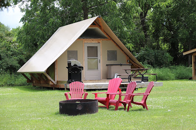
These structures are called Otentiks. They are a combination cabin and tent at various Parks Canada sites. These two are part of the Upper Nicholsons lockstation. They can sleep as many as six people and can be rented for a reasonable rate with a prior reservation with Parks Canada. For more information on them check out Parks Canada's web site
Otentik page.
I only took the two pictures and did not get closer for a more detailed walk around as there were people occupying them and I wanted to maintain their privacy.


