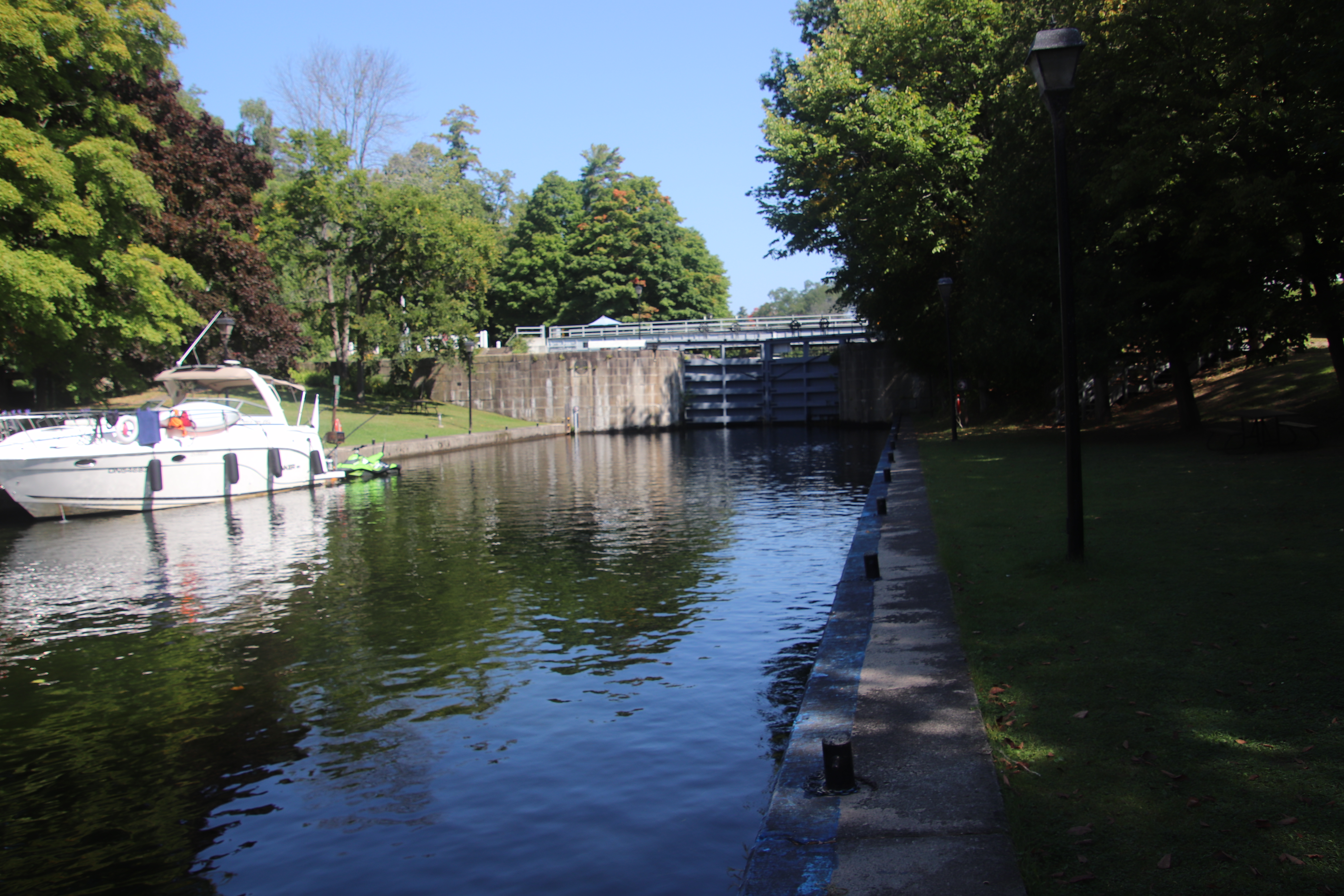
Chaffeys Lockstation occupies a location at the west end of Chaffeys Lock Road. At Chaffeys lock the road changes to Opinicon Road.


Rideau Canal
National Historic Site of Canada
Chaffeys Lock
Canal-Rideau
Lieu historique national du Canada
Écluse de Chaffeys
National Historic Site of Canada
Chaffeys Lock
Canal-Rideau
Lieu historique national du Canada
Écluse de Chaffeys


When the surveyors arrived at this site they found in busy operation a small complex of mills, which was not as difficult as it might seem since Colonel John By was armed with full powers of expropriation. All along the route, owners of lands could, and usually did, argue at great length about the value of their lands, sometimes for years after the waterway was finished, but they could not delay or prevent the Royal Engineers taking what was necessary.
By looking down through the clear water in the lock, you can see that the walls of the chamber are built right on the bedrock, which here is close to the surface and free of fissures through which water could leak. Many of the oher locks on the system are on much less stable ground, so they are build as an inverted, or upside down arch. Regardless of the style of construction, building with stone requires much skill to ensure that masonry does not fall to pieces after the frosts of a few winters.
Between 1826 and 1832, an old Indian canoe route along the Rideau and Cataraqui Rivers was transformed at the command of the British government from untamed wilderness rivers into the Rideau Canal. The purpose of this remarkable artery was to provide the British army with a safe route for supplying its inland garrisons, avoiding the direct but exposed route along the St. Lawrence, which only the disorganization of the American forces had prevented from being cut during the War of 1812.
The 202 km (126 miles) of waterway was made navigable by 47 locks grouped in 24 stations with their associated dams and weirs. The word was designed and superintended by the Royal Engineers, commanded by Lieutenant Colonel John By; the actual construction was done by local contractors.
Despite the blockhouses along the waterway, the role of the Rideau has always been peaceful. It was a busy waterway, carrying settlers and supplies into the growing settlement of the interior until the middle of the 19th century, when larger locks were opened on the St. Lawrence. At the same time, since the possibility of war between Britain and the United States was now unlikely, the British Board of Ordnance signed the system over to the colonial government of Canada in 1856. The period of the Canal's military administration was over.
Local commercial traffic remained important until the advent of the automobile and better roads about the time of World War 1. Since that time recreational boating has grown steadily so that now the system, well into its second century, is busier than ever.

Lorsque les arpenteurs sont arrivés ici, ils ont trouvé quelques petits moulins en pleine exploitation appatenant à la famille Chaffey. Pour contruire l'écluse, il fallut démolir les moulins. Cela ne fut pas si difficile, compet tenu des pouvoirs d'expropriation que détenait le colonel John By. Tous les expropriés le long du canal pouvaient contester la valeur de leurs terrains. La plupart l'ont fait, même après la construction du canal, mais ils ne pouvaient empêcher les Royal Engineers d'exproprier les terrains nécessaires aux travaux.
L'eau limpide de l'écluse permet de constater que les murs du bief reposent directement sur l'assise rocheuse où il n'y a pas de fissures par lesquelles l'eau pourrait s'écouler. De nombreuses autre écluses s'élèvent sur un sol beaucoup moins solide: c'est pourquoi elles sont construites comme un arche inversée. Quel que soit le style, il faut beaucoup de soin et d'habileté pour faire des constructions en pierre, puisqu'il faut s'assurer que la maçonnerie résistera au gel de quelques hivers.
Entre 1826 et 1832, une ancienne voie d'eau utilis e par les Indiens le long des rivières Rideau et Cataraqui fut transformée à la demande du gouvernement britannique en un réseau de voies navagables : le canal Rideau. Le but de cet ouvrage remarquable était de fournir à l'armée britannique une route sûre pour approvisionner ses garnisons. On évitait ainsi le Saint-Laurent, voie plus directe mais oussi plus dangereuse qui n'était demeurée ouverte qu'en raison de la désorganisation de l'armée américaine au cours de la guerre de 1812.
Le réseau de 202 km (126 milles) a été rendu navigable par la construction de 47 écluses regroup es en 24 postes. Les travaux ont été planifiés et surveillés par les Royal Engineers. Sous le commandement du lieutenant-colonel John By. Ils ont été exécutés par des entrepreneurs locaux.
Malgré les blockhaus qui se trouvent le long du réseau, le Rideau n'a jamais été troublé par la guerre. Ce fut un cours d'eau achalandé transportant colons et approvisionnement l'int rieur des terres jusq'au milieu de XIXe siècle lorsque les grandes écluses du Saint-Laurent furent ouvertes à la navigation. Au même moment, la menace de guerre entre la Grande-Bretagne et les États-Unis s'étant estompée, le British Board of Ordnance céda le réseau au gouvernement colonial du Canada en 1856. Ceal mit fin à l'administration militaire du canal.
Le trafic commercial local demeura important jusqu'à l'apparition de l'automobile et la construction de meilleurs routes à l'époque de la Premi re Guerre mondiale. Depuis, les plaisanciers se sont faits de plus en plus nombreux, tant et si bien qu le réseau, qui en est à son deuxième siécle d'existence, et maintenant plus fréquent que jamais.

Parks Canada welcomes visitors from around the globe to one of the world's largest and most diverse park systems, featuring some of Canada's most important natural and cultural treasures. In this family of special places, there are national parks, national marine conservation areas, national historic sites and historic canals. At this time, twelve world heritage sites are designated in Canada, of which eight include in whole or in part, Parks Canada managed properties.
Canada's national historic canals vary from single locks to complex systems of interconnected locks, channels and natural waterways. The canals trace the routes of exploration, defence, commerce and transportation which helped shape Canada. Today they are extensive cultural and natural heritage corridors that preserve natural beauty and rich heritage and connect Canadians with their history.
Nine historic canals are maintained and operated by Parks Canada. Cape Breton Island's salt-water heart, Bras d'Or Lake, is reached through Nova Scotia's St. Peters Canal. Five canals in Quebec bypass the shallows and rapids of historic lifelines of early Canada; the St. Lawrence, Ottawa and Richelieu rivers. Ontario's Trent-Severn Waterway and Rideau Canal weave passages through the province's interior lakes and rivers, and the Sault Ste. Marie Canal completed an all-Canadian Great Lakes navigation system.
When you visit Parks Canada national parks and national historic sites, you can be confident you will bring home many wonderful memories of exciting and enriching experiences.
CANADA'S NATIONAL PARKS AND NATIONAL HISTORIC SITES

Parcs Canada souhaite la bienvenue aux visiteurs du monde entier à son réseau. l'un des plus vastes et des plus diversifiés de la planète, et les invite à admirer quelques-uns de ses plus imporatnts trésors naturels et culturels. Ce réseau compte des parcs nationaux, des aires marines nationales de conservation, des lieux historiques nationaux et des canaux historiques. En outre, douze des sites du patrimoine mondial sont situés au Canada et huit d'entre eux renferment en tout ou en partie des sites administr s par Parcs Canada.
Les canaux historiques de Parcs Canada sont diversifiés : écluses individuelles, réseaux complexes d'écluses interreliées, chenaux et voies d'eau naturelles. Les canaux sont les voies d'exporation, de défense, de négoce et de transport qui ont permis de façonner le Canada. Aujourd'hui, ce sont d'importants corridors naturels et culturels qui préservent la beauté de la nature de m me qu'un riche patrimoine et qui rattachent les Canadiens à leur histoire.
Parcs Canada entretient et exploite neuf canaux historiques. Le canal de St. Peters en Nouvelle-Écosse consuit au Bras d'Or, étendue d'eau salée au cœur de L'île du Cap-Breton. Au Québec, cinq canaux permettent de contourner les eaux peu profondes et les rapides des cours d'eau qui ont marqué les débuts de notre pays, savoir : le fleuve Saint-Laurent, la rivi re des Outaouais et la rivi re Richelieu. La voie navigable Trent-Severn et le canal Rideau en Ontario donnent acc s aux lacs et aux rivi res de l'interieur de la province. Quant au canal de Sault Ste. Marie, il a été le point final du réseau de navigation canadien des Grands Lacs.
Soyez assuré qu'une visite aux parcs nationaux et aux lieux historiques nantionaux de Parcs Canada sera riche en souvenirs et en expériences passionnantes et stimulantes.
LES PARCS NATIONAUX ET LES HISTORIQUES NATIONAUX DU CANADA


THE TREES ON MILL POINT
ARE PLANTED BY THE FRIENDS OF
ARTHUR L. PHELPS
1888 — 1970
IN HIS MEMORY
PLAQUE BY
THE HERMAN WARREN
FAMILY
ARE PLANTED BY THE FRIENDS OF
ARTHUR L. PHELPS
1888 — 1970
IN HIS MEMORY
PLAQUE BY
THE HERMAN WARREN
FAMILY

LES ARBRES DE MILL POINT
ONT ÉTÉ PLANTÉS PAR LES AMIS D'
ARTHUR L. PHELPS
1888 — 1970
À SA MÉMOIRE
PLAQUE DE
LA FAMILLE
HERMAN WARREN
ONT ÉTÉ PLANTÉS PAR LES AMIS D'
ARTHUR L. PHELPS
1888 — 1970
À SA MÉMOIRE
PLAQUE DE
LA FAMILLE
HERMAN WARREN