In Ottawa, Ontario, the site with provincial and federal plaques about Carlsbad Springs and a bath house occupies the south side of Russell Road west of Spring Street.
À Ottawa, en Ontario, le site comportant des plaques provinciales et fédérales concernant Carlsbad Springs et un établissement de bains occupe le côté sud de Russell Road, à l'ouest de Spring Street.


CARLSBAD SPRINGS
Bear Brook is a tributary of the South Nation River, which drains into the Ottawa River near Plantagenet. In the early days of settlement, logs were floated down to mills during the spring break-up. Settlers also used the river for transportation to their new homesteads. However, due to its small size and low water during summer, its use for transporting settlers and their goods did not continue long after the opening of the Russell Road. The completion of the Canada Atlantic railway in 1882 provided a better solution for shipping of timber and lumber, and for general transportation.
Today, Bear Brook flows mainly through farmland. Its waters drain away faster, now that a mature forest no longer exists. This quiet walk through the woods is a chance to savour the atmosphere that likely prevailed in an earlier period. Beaver and their works can be observed, as well as many small animals. Viewing of waterfowl and other birds can also be enjoyed along this pathway.

CARLSBAD SPRINGS
Le ruisseau Bear est un affluent de la rivière Nation Sud qui se jette dans la rivière des Outaouais près de Plantagenet. Au début de la colonisation il servait à acheminer des billots en aval vers les scieries durant la débâcle du printemps. Les colons aussi s'en servaient pour rejoindre leurs nouvelles terres ancestrales. À cause de l'étroitesse du cours d'eau et de son faible début durant l'été, son utilisation pour transporter les colons et leurs biens fut abandonnée peu après la construction du chemin de Russell. Le parachèvement du chemin de fer Atlantique-Canadien ent 1882 offrait une meilleure solution pour l'expédition de bois d'œuvre et de sciage, et pour le transport en général.
Aujourd'hui, le ruisseau Bear traverse principalement des terres agricoles. La forêt mature ayant disparu, il s'assèche plus rapindement. Le sentier silencieux à travers des boisés permet s'imprégner de l'ambience d'antan. Il donne l'occasion d'observer les castors et leur travail, de nombreux petits animaux ainsi qui plusieurs esoèces d'oiseaux et de sauvagines.


CARLSBAD SPRINGS
During the first years of settlement, the area of the mineral springs was cleared of trees and later landscaped. Many of the original trees along the Russell Road were harvested to obtain income as settlers developed their homesteads. The surrounding areas remained densely wooded until settlement was complete. Sawmills operated near this site in the period 1854-1905. When the first stopping place was built, in 1852, this road was but a dirt track, with a wooden bridge across the Bear Brook.
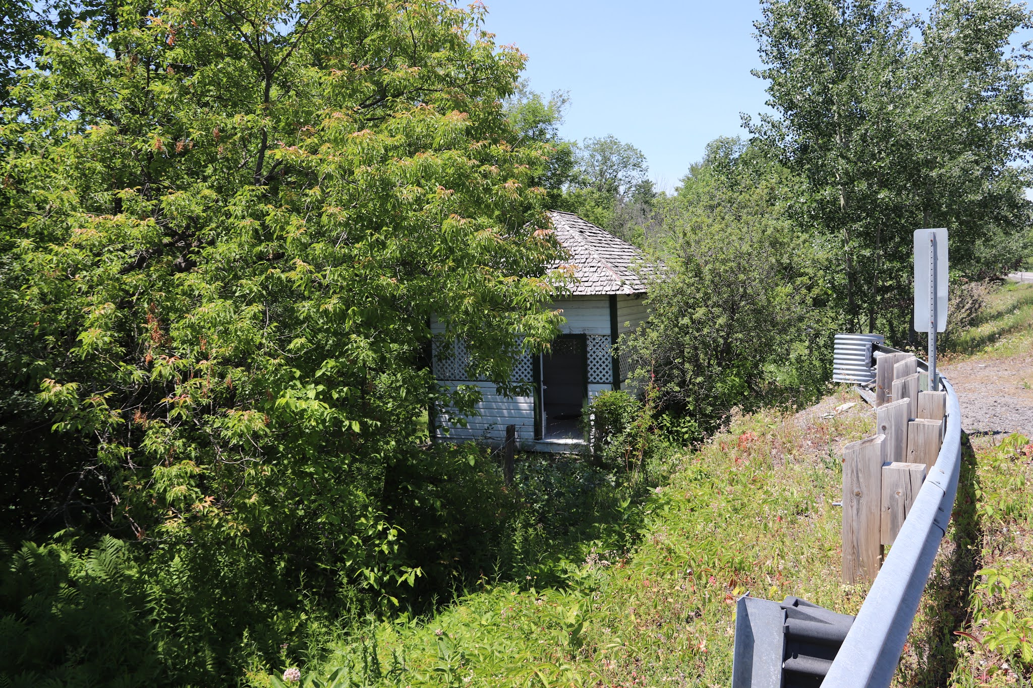
The original well houses were round. After the site was redesigned in 1908, five or six square houses replaced the originals: the only surviving one is near the historical plaque. Water for the wells came from an underlying aquifer where it is forced upward by pressure from waters entering the ground at higher elevations beyond the road. This water may have travelled through bedrock for hundreds of years before surfacing in this area. The waters of the various wells tasted differently, and tests showed a variety of chemical properties. Hence the wells were given names such as Sulphur, Lithia, Soda, Magic and Gas. Later, most of the springs were buried when the Russell Road was straightened and upgraded in the 1970s.

CARLSBAD SPRINGS
Au cours de premières années de la cononisation, la zone des sources minérales fut déboisée, puis ultérieurement paysagée. De nombreaux arbres qui se trouvaient originalement le long du chemin de Russell ont été récoltés pour procurer un revenu aux colons qui s'installaient sur leurs terrs ancestrales. Les enirons sont demeurés des forêts denses jusqu'à la fin de la colonisation. Des scieries étaient actives près de cet endroit de 1854 à 1905. Lorsque la première halte fut construiite en 1852, la route n'était qu'une piste et un pont en bois traversait le ruisseau Bear.
Les maisons des sources originales étaient rondes. Lorsque le site fut réaménagé en 1908, cinq ou six maisons carrées on pris leur place. L'eau des sources provient d'un aquifère souterrain. Elle remonte à la surface à cause de la pression exercée par l'eau pénétrant dans la sol à partir de points plus élevés de l'autre côte du chemin. L'eau des sources peut avoir traversé le substrat rocheux pendant des centraines d'années avant de laillir ici. Les eaux des différentes sources ont un goût différent et leur analyse indique qu'elles ont diverses propriétés chimiques. Par conséquent on les appelé Sulphur (soufre), Lithia (lithium), Soda (carbonate de sodium) Magic (aux propriétés magiques) et Gas (gazéifiée). La plupart des sources ont été bouchées lorsque le chemin de Russell a été redressé et amélioré dans les années 1970.


CARLSBAD SPRINGS
In the 1860s, local innkeeper Daniel Eastman offered water from the natural mineral springs in this area for drinking and bathing. His inn was followed by larger hotels where guests were invited to "take the waters" for ailments such as rheumatism, nervousness and digestive disorders. Eastman's Springs was soon a fashionable meeting place for Ottawa society. Also known as Cathartic, it became Carlsbad Springs by the early twentieth century when the Boyd family, owners of the largest hotel named their establishment after a famous European spa. By supplementing spa therapy with social and recreational activities the resort's four hotels remained popular until the Second World War. This springhouse was part of the Boyd spa complex.
Ontario Heritage Foundation, an agency of the Government of Ontario
CARLSBAD SPRINGS
Dans les années 1860, l'aubergiste Daniel Eastman offre l'eau minérale naturelle des sources de cette région comme boisson et pour des bains. Puis viennent des hôtels plus grands, où les clients vont faire une « cure d'eaux �» contre le rhumatisme, le nervosité et les troubles digestifs. Les sourcces d'Eastman deviennent alors le rendez-vous mondain de la bonne société d'Ottawa. Également appelées Cathartic, elles prennent le nom de Carlsbad Sprins au début du vingtième siècle, lorsque la famille Boyd, propriétaire du plus grand hôtel, nomme celui-ci d'après la célebre ville d'eaux européenne. Les quatre hôtels, qui offrent, en plus des bains thérapeutiques, des activités mondaines et de loisirs, gardent leur popularité jusqu'à la Seconde Guerre mondiale. Ce pavillon de la source faisait partie de l'établissement de bains des Boyd.
Fondation du patrimoine onterien, un organisme du gouvernement de l'Ontario