The Clowes Lockstation occupies a location on the northwest side of the Rideau River. The entrance driveway to the lockstation lies on Heritage Drive about 300 meters southwest of the intersection with Andrewsville Main Street.
 |
You are located at:
Clowes Crown House
Vouse êtes au:
Logemenet de la Couronne de Clowes
495 promenade Heritage Drive |
This defensible lockmaster's house, located in an elevated position distant from the Clowes lock, is a recognized Federal Heritage Building, designed by Royal Engineers and designated as a heritage building on April 30, 1992.
CLOWES
This is now a peaceful site, but the defensible lockmaster's house on the rise to the north is a reminder that the builders of the lock were prepared to defend it against a possible invader. One of the contractors who worked on the lock and dam, James Clowes, supplied the stone from his nearby quarry and his name for the station. Alas, because of poor workmanship, he lost his contract.
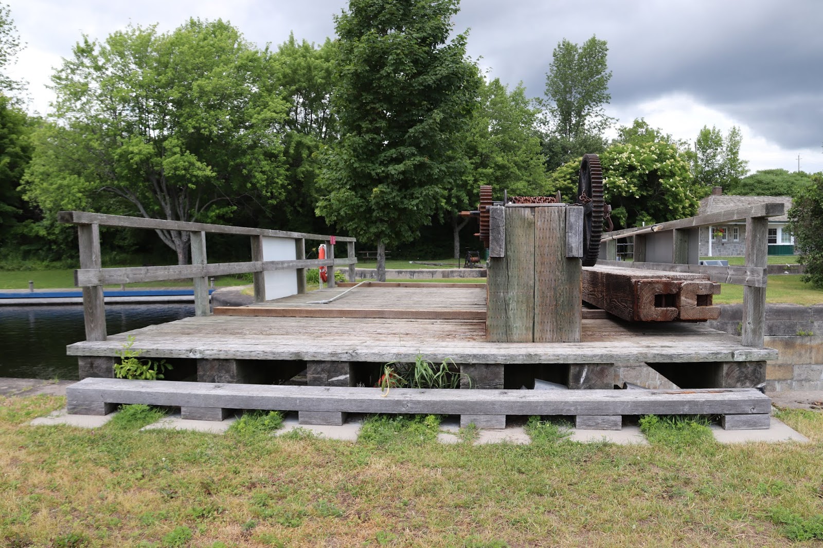
The dam here, one of the overflow type designed to have the water flow over the top, is provided with a waste weir, or bywash, on the west side of the dam. This acts as a type of safety valve during spring floods. It can control the flow over the top at other seasons to help reduce erosion caused by the force of falling water on soft rock along the dam's foundations. Waste weirs were originally installed by the contractors as temporary measures to divert the river during construction, but Colonel By soon recognized their usefulness and incorporated them into the permanent works.
Between 1826 and 1832, an old Indian canoe route along the Rideau and Cataraqui Rivers was transformed at the command of the British government from untamed wilderness rivers into the Rideau Canal. The purpose of this remarkable artery was to provide the British army with a safe route for supplying its inland garrisons, avoiding the direct but exposed route along the St. Lawrence, which only the disorganization of the American forces had prevented from being cut during the War of 1812.
The 202 km (126 miles) of waterway was made navigable by 47 locks grouped in 24 stations with their associated dams and weirs. The word was designed and superintended by the Royal Engineers, commanded by Lieutenant Colonel John By; the actual construction was done by local contractors.
Despite the blockhouses along the waterway, the role of the Rideau has always been peaceful. It was a busy waterway, carrying settlers and supplies into the growing settlement of the interior intul the middle of the 19th century, when larger locks were opened on the St. Lawrence. At the same time, since the possibility of war between Britain and the United States was now unlikely, the British Board of Ordnance signed the system over to the colonial government of Canada in 1856. The period of the Canal's military administration was over.
Local commercial traffic remained important until the advent of the automobile and better roads about the time of World War 1. Since that time recreational boating has grown steadily so that now the system, well into its second century, is busier than ever.
CLOWES
C'est aujourd'hui un endroit paisable, mais la maison fortifiée du maître-éclusier, au nord, sur la colline, rappelle que les constructeurs de l'écluse étaient prêts à la défendre contre tout envahisseur. L'un des entrepreneurs qui ont construit l'écluse et le barrage, James Clowes, a fourni la pierre provenant de sa carrière. On donna son nom à l'écluse. Il perdit toutefois le contrat en raison d'un manque de travailleurs compétents.
Le barrage a été conçu de façon à ce que l'eau s'écoule par-dessus. Il est doté d'un déversoir du côté ouest. Il s'agit en quelque sorte d'une soupape de sûreté ulitle au moment des crues printanières. Le déversoir retient l'eau en d'autres saisons, ce qui réduit l'érosion causée par la force de l'eau qui se déverse sur le roc friable en bordure des fondations. Les déversoirs ont été installés temporairement par les constructeurs pour détourner le cours de la rivière pendant la durée des travaus. Le colonel By a cependant vite reconnu leur utilité et les a intégrés dns les travaux permanents.
Entre 1826 et 1832, une ancienne voie d'eau utilisée par les Indiens le long des rivières Rideau et Cataraqui fut transformée à la demande du gouvernement britannique en un réseau de voies navagables : le canal Rideau. Le but de cet ouvrage remarquable était de fournir à l'armée britannique une route sûre pour approvisionner ses garnisons. On évitait ainsi le Saint-Laurent, voie plus directe mais oussi plus dangereuse qui n'était demeurée ouverte qu'en raison de la désorganisation de l'armée américaine au cours de la guerre de 1812.
Le réseau de 202 km (126 milles) a été rendu navigable par la construction de 47 écluses regroupées en 24 postes. Les travaux ont été planifiés et surveillés par les Royal Engineers. Sous le commandement du lieutenant-colonel John By. Ils ont été exécutés par des entrepreneurs locaux.
Malgré les blockhaus qui se trouvent le long du réseau, le Rideau n'a jamais été troublé par la guerre. Ce fut un cours d'eau achalandé transportant colons et approvisionnement à l'intérieur des terres jusq'au milieu de XIXe siècle lorsque les grandes écluses du Saint-Laurent furent ouvertes à la navigation. Au même moment, la menace de guerre entre la Grande-Bretagne et les États-Unis s'étant estompée, le British Board of Ordnance céda le réseau au gouvernement colonial du Canada en 1856. Ceal mit fin à l'administration militaire du canal.
Le trafic commercial local demeura important jusqu'à l'apparition de l'automobile et la construction de meilleurs routes à l'époque de la Première Guerre mondiale. Depuis, les plaisanciers se sont faits de plus en plus nombreux, tant et si bien qu le réseau, qui en est à son deuxième siècle d'existence, et maintenant plus fréquenté que jamais.
The weir is the small dam that controls the upstream water's height and protects the main dam and locks from high water and flooding during the spring thaw. The height of the weir, and consequently the amount of water flowing through it, is regulated by adding or removing wooden beams to the weir's gate.