

The Hogs Back Lockstation incorporates locks 11 and 12, a swing bridge and a weir - a dam to control the water level upstream of the lockstation. I'll start with the weir and the drop to the north of it, followed with the upstream Rideau River, then the swing bridge and finally the lockstation's locks.


Hogs Back Falls: formed and re-formed
The rocky landscape around you, had its beginnings some four hundred and fifty million years ago. Lime-based mud and sand were deposited in an ancient marine basin. Thes muds and sands underwent the natural processes of compaction, compression, upheaval and erosion. Fifteen thousand years ago, continental glaciers cover the area with a blanket of ice two kilometres thick. This ice melted eleven thousand years ago. The Ottawa Valley was then invaded by the Champlain Sea. Movements within the earth's crust caused the sea to withdraw and disappear, leaving behind a rugged landscape with outcrops of limestone, sandstone and shale.
Nine thousand years ago the Rideau was a much wider river. Further adjustments in the earth's crust resulted in structural changes within the rocks and to the shape of the river channel and local landscape.
Two hundred years ago, here, in the midst of a dense forbidding forest, a spectacular falls with a set of 3 treacherous rapids roared. One of the rocky ridges, no longer visible, rose above the foaming waters and looked like the back of a swine. Early loggers named the area Hogs Back Falls.
Construction of the Rideau Canal, between 1826 and 1832, destroyed the natural shape of the falls. A retaining dam reduced its width. A weir served to control the flow of water over its crest. Blasting and excavation shifted the course of the water flow. Additional modification and re-design of the engineering structures over the last century and a half have further altered the appearance of the falls.
Despite the numerous human manipulations, Hogs Back Falls remains a natural attraction - a wild place in the midst of an orderly cityscape.

Les chutes de Hogs Back: création et récréation
Le paysage rocheux qui vous entoure date de quelque quatre cent cinquante millions d'années. Les boues et les sables calciares sont de dépôts d'un ancien bassin marin qui ont subi l'évolution naturelle du compactage, de la compression, du soulèvement et de l'érosion. Il y a quinze mille ans, les glaciers continentaux recouvraient la région d'une couche de glace de deux kilomètres d'épaisseur. Cette glace a fondu, il y a onze mille ans. La vallée de l'Outaouais a enswuite été envahie par la mer de Champlain. Les mouvements de la croûte terrestre ont entrainé le retrait et la disparition de la mer qui a laissé derrière elle un paysage accidenté parsemé de roche calcaire, de grès et de schiste argileux.
Il y a neuf mille ans, la rivière Rideau était plus large. D'autres mouvements de la croûte terrestre ont entrainé des changements structuraux des rochers et ont modifié le cours de la rivière. L'érosion qui s'est faite pendant des milliers d'années a aussi modifié le lit de la rivière et le paysage avoisinant.
Il y a deux cent ans, ici même, au beau milieu d'une forêt inhospitalière, grondaient les eaux de chutes spectacuaires à trois rapides dangereux. L'une des crêtes rocheuses, qu'on ne voit plus maintenant, s'élevait au-dessus des eaux bouillonnantes et ressemblait à l'échine d'un porc. Les premiers bûcherons nommèrent alors la région des chutes au dos de porc ou Hogs Back.
La construction du canal Rideau, entre 1826 et 1832, détruisit la forme naturelle des chutes. Un barrage de retenue en réduisit largeur. Un déversoir servit à régulariser le débit d'eau. Des travaux de dynamitage et d'excavation modifièrent le cours des eaux. D'autres modifications et révisions de la conception des ouvrages de génie civil au cours du siècle et demi dernier ont également modifié l'apparence des chutes.
Malgré les nombreuse interventions humaines, les chutes de Hogs Back demeurent un attrait naturel - un région sauvage au milieu d'un paysage urbain ordonné.


A Saga or try, try and try again...
For Lt. Colonel John By, the engineering challenge was to create a simple navigation route from this location on the Rideau Canal to its terminus at Ottawa Locks. The solution was to raise the water level of the river, here, to that of Black Rapids, located 6.4 kilometres upstream.
Original plans of 1827 called for a 14 metre high stone arched keywork and earthen dam stretching across the entire river. After three failures due to spring thaws and floods, the last of which almost took the life of Colonel By, the design was abandoned. Instead the dam consisted of a gigantic wooden crib fortified by earth and rock filled on both sides. To ensure water never flowed over the dam, its height was increased to 15 metres. A weir served to control the water flow.
Despite these precautions, repairs and re-modelling were undertaken in every decade between 1840 and 1940. The work was necessary due to the damage to structures caused by spring flooding, ice and driftwood. The evolving needs arising from commercial use, settlement, development and new technologies also played a role.
In the 1970s Parks Canada, in partnership with the National Capital Commission, undertook the last major re-construction. The concrete was renewed in the water-control dam. Electric gates were installed in two weirs. The fixed bridge over the water-control dam was widened as well as the road over the retaining dam. The swing bridge over the locks was replaced wtih a wider hydraulic-electric model. What you see today is the result.

Cent fois sur le métier remettez votre ouvrage...
Le lieutenant-colonel By devait réaliser la prouesse technique d'une voie de navigation simple, d'ici sur le canal Rideau jusq'aux écluses d'Ottawa. Pour ce faire, il lui fallait, en cet endroit, hausser le niveau de l'eau jusqu'à celui de Black Rapids situé en amont à 6,4 kilomètres.
Les plans originaux de 1827 prévoyaient un barrage-voûte en pierre de 14 mètres de haut et un barrage en terre sur toute la largeur de la rivière. Après trois essais infructueux attribuables aux dégels et aux inondations du printemps, dont la dernière faillit emporter le colonel By, on abandonna cette solution. On construisit à la place un barrage composé de gigantesques encoffrements de charpente renforcés de part et d'autre par de la terre des roches. Pour que l'eau ne passe jamais par-dessus le barrage, on le construisit à 15 mètres de hauteur et un déversoir servit à régularisr le débit.
Malgré ces précautions, il fallut effecteur des réparations et modifier la conception tous les dix ans entre 1840 et 1940. Il fallait bien réparer les dommages subis par les ouvrages en raison des inondations printanières, de la glace et du bois à la dérive et les adapter aux besoins engendré par le transport commercial, la colonisations, l'aménagement et les nouvelles technologies.
À la fin des années 70, Parcs Canada, en collaboration avec la Commission de la capitale nationale, entreprit la dernière grande reconstruction. On renouvela le béton du barrage de régularisation des eaux. On installa de portes électriques dans deux déversoirs. Le pont fixe au-dessus du barrage de régularasation des eaux fut élargi, tout comme la rout au-dessus du barrage de retenue. Le pont tournant aux écluses fut remplacé par un modèle hydraulique-électrique plus large. C'est ce résultat que vous observerz aujourd'hui.

 |
| Lock your Love ↑ and throw the key |


These rocks, sandstones and limestones were formed on the bottom of a shallow sea which coverd this region in Ordovician time some 400 million years ago. Not the ripple marks formed by the ancient waves.
Later the region was uplifted and the strata here were folded and broken. A major break or fault can be seen at low water just below the east end of the bridge.
The present course of the river over these rocks was established at a still much later date.
Scientific Site
Information by Geological Survey of Canada


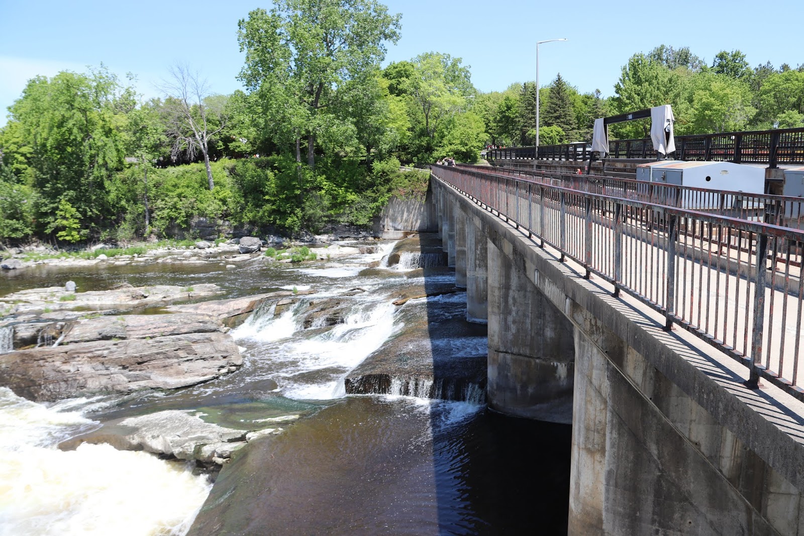

This is the walkway on the top of the weir, facing east. Hogs Back Road is on the right to the south.


Impressive Landscape! Imposing Engineering!
Foaming white water, a ragged collection of rock cliffs and ledges and a massive concrete dam enclosed in a city park setting. This eclectic landscape begs an explanation.
Before you is the Hogs Back water-control dam. It serves to harness the waters of the Ridea River. The dam is one of the engineering structures in a bigger site complex stretching to the opposite side of the river.
The site is part of the Rideau Canal - water-control dam, retaining dam, lookout point and lockstation. Opened in 1832, this 202 kilometre waterway links Lake Ontario at Kingston and the Ottawa River, here, in the Nation's Capital. One of Canada's historic canals, the Rideau is a member of a unique family, which includes national parks, national historic sites and national marine parks protected and presented to highlight our heritage.
We invite you to take twenty minutes and walk the entire site. Interpretive panels along the way reveal the dramatic and sometimes drastic events of the las one hundred and sixty plus years that have shaped the Hogs Back landscape you see today.

Paysage impressionnant! Ouvrages de génie civil imposants!
Eu blanche écumante, falaises et saillies rocailleuses, massif barrage de béton, au beau milieu d'un parc urbain. Ce paysage éclectique mérite explication.
Vous voyez devant vous le barrage de régularisation des eaux de Hogs Back. Il sert à dompter les eaux de la rivière Rideau. Le barrage, un des ouvrages de géne civil, fait partie d'un complexe plus vaste qui s'étend jusque de l'autre côté de la rivière.
Le site fait partie du Canal Rideau : le barrage de régularisation des eaux, le barrage de retenue des eaux, le belvédère et le poste d'éclusage. Inaugurée en 1832, cette voie navibable de 202 kilomètres relie la lac Ontario, à Kingston, et la rivière des Outaouais, ici dans la région de la capitale nationale. Au nombre des canaux historiques dur Canada, le Rideau fait partie d'une famille exceptionelel qui comprend les parcs nationaux, les lieux historiques nationaux, les parc marins nationaux, tous protégés et mis en valeur au profit de notre patrimoine.
Nous vous invitons à consacrer une vingtaine de minutes à la visite lieux : des panneaux d'interprétation tout le long du parcours vous révéleront les événements spectaculaires, parfois dramatiques des quelque cent soixante années qui ont façonné le paysage de Hogs Back que vous voyez aujourd'hui.


What about this point?
Prior to canal construction, this point did not exist. It took its initial form from the fill used to build and secure the retaining dam. The present triangular shape was included in the massive reconstruction work of the dams, roads and bridges in the mid-1930s.
In response to the recreational popularity of the Hogs Back area, the point was developed into a public beach. Ongoing safety problems of dangerous waters and inadequate facilities forced it to close in 1958. The present layout of pathways and landscaping was put in place as part of the last major renewal and modification in the late 1970s.

Histoire de la pointe?
Avant la construction du canal, cette pointe n'existait pas. La terre de remplissage utilisée pour construire et fortifier le barrage de retenue lui donna sa forme initiale. La pointe prit la forme triangulaire qu'on lui connait aujourd'hui avec les grans travaux de reconstruction des barrages, des routes et des ponts, au milieu des années 30.
Devant la popularité de la région de Hogs Back comme endrot de villégiature, la pointe est devenue une plage publique. Des probleèmes constants de sécurité, en raison des eaux dangereuses et des installations insuffisantes, en ont forcé la fermeture en 1958. L'aménagement actuel des sentiers et l'aménagement paysager ont fait partie des derniers grands travaux de modernisation et de modificiation etrepris dans la région à la fin des années 70.

A Parting of the waters...
For almost 193 kilometres the Rideau Canal follows the natural courses of the Cataraqui and Rideau Rivers. Completed in 1832, a succssion of retaining dams to raise water levels, weirs to regulate water flow and 47 locks to pass boats made the rivers into a navigable waterway.
At this location, the Canal separates from the natural river route. For the Canal's builder, Lt. Colonel John By, a separate artificial channel was the only solution to overcome the 35 metre (115 ft.) drop in the natural river channel between this point and its mouth.
To the west, is the entrance to the artificial channel - Hogs Back Lockstation. This channel carries the Canal its last 8.5 kilometres, meeting the Ottawa River at Ottawa Locks. To the east, is the river channel. It continues past the retaining dam, water control dam and falls, emptying into the Ottawa River at Rideau Falls.
Today the serene and manicured stting around this point reveals nothing of the hardships and herculean efforts require to build and maintain the engineering works at Hogs Back Lockstation. Imagine, it took canal surveyors three days, slogging through forest and swamp, to reach this site from what is now downtown Ottawa!

Partage des eaux...
Le canal Rideau suit, sur près de 193 kilomètres, les méandres naturels des rivières Cataraqui et Rideau. Ces rivières devinrent, à l'achèvement des travaux en 1832, une voie navigable composée d'une suite de barrages de retenue visant à faire monter le niveau d'eau, de déversoirs visant à régulariser le débit d'eau et de 47 écluses pour laisser passer les bateaux.
Ici, le canal ne suit plus le cours naturel de la rivière. Le lieutenant-colonel By, constructeur du canal, voyait en un chenal artificiel distinct le seul moyen de surmonter l'obstacle de la dénivellation de 35 mètres dans le lit de la rivière entre ici et son embouchure.
À l'ouest est l'entrée du chenal artificiel, le poste d'éclusage de Hogs Back. Ce chenal prolonge le canal sur ses derniers 8,5 kilomètres, où il rejoint la rivière des Outaouais, aux écluses d'Ottawa. À l'est, est la rivière proprement dite qui va au-delà du barrage de retenue, du barrage de régularisation des eaux et des chutes, pour se jeter dans la rivière des Outaouais, aux chutes Rideau.
Aujourd'hui, le décor paisible et soigné ne vous révèle rien des misères et des efforts herculéens qu'ont dû déployer les travailleurs pour construire et entretenir les ouvrages de génie civil au poste d'éclusage de Hogs Back. Imaginez, partis de ce qui est maintenant le centre de la ville d'Ottawa, les arpenteurs du canal ont mis trois jours por parvenir jusqu'ici, à travers bois et marécages!


HOGS BACK
This is the location where the natural course of the Rideau River diverts from the man-made channel of the Rideau Canal that winds its way through Ottawa.
To tame the rapids and raise the water to provide proper navigation depth, Colonel John By proposed a massive stone dam to extend across the channel of the Rideau River. The contractor, Walter Fenlon, started work on this dam in 1827. Spring flooding in 1828 washed most of the dam away and the Royal Engineers with assistance of the contractor, Philemon Wright, took over the project. The extreme cold of the winter of 1828-29 froze the clay that was being used to form a watertight barrier. This allowed spring floodwater to penetrate the dam and on April 3, 1829 a leak was spotted. Colonel By stated that he "was standing on top of it [the dam] with forty men employed in trying to stop the leak when I felt a motion like an earthquak and instantly ordered the men to run, the stones falling from under my feet as I moved off."
After this failure, By abandoned his plans for a stone dam and instead used a timber crib dam with a control weir to tame the mighty Rideau.
Between 1826 and 1832, an old Indian canoe route along the Rideau and Cataraqui Rivers was transformed at the command of the British government from untamed wilderness rivers into the Rideau Canal. The purpose of this remarkable artery was to provide the British army with a safe route for supplying its inland garrisons, avoiding the direct but exposed route along the St. Lawrence, which only the disorganization of the American forces had prevented from being cut during the War of 1812.
The 202 km (126 miles) of waterway was made navigable by 47 locks grouped in 24 stations with their associated dams and weirs. The word was designed and superintended by the Royal Engineers, commanded by Lieutenant Colonel John By; the actual construction was done by local contractors.
Despite the blockhouses along the waterway, the role of the Rideau has always been peaceful. It was a busy waterway, carrying settlers and supplies into the growing settlement of the interior intul the middle of the 19th century, when larger locks were opened on the St. Lawrence. At the same time, since the possibility of war between Britain and the United States was now unlikely, the British Board of Ordnance signed the system over to the colonial government of Canada in 1856. The period of the Canal's military administration was over.
Local commercial traffic remained important until the advent of the automobile and better roads about the time of World War 1. Since that time recreational boating has grown steadily so that now the system, well into its second century, is busier than ever.
HOGS BACK
Ici la rivière Rideau reprend son cour naturel, après avoir coulé dans le cnal éponyme qui traverse Ottawa.
Pour faciliter le passage des rapides et obtenir la profondeur nécessaire à la navigation, le colonel John By avait proposé la construction d'un barrage massif en pierres qui enjamberait le chanal de la rivière Rideau. L'entrepreneur, Walter Fenlon, commença les travaux en 1827. Les crues printanières de 1828 emportèrent la presque totalité du barrage et les Royal Engineers, avec l'aide de l'entrepreneur Philemon Wright, prirent le projet en main. Le froid extrême de l'hiver 1828-1829 fit geler l'argile utilisée pour former une barrière étanche. Les eaux de la crue printanière purent donc pénétrer dans le barrage et, le 3 avril 1829, une fuite se produisit. Le colonel By raconte qu'il se trouvait sur le barrage avec quarante hommes en train d'essayer de colmater la fuite lorsqu'il sentit un mouvement semblable à un tremblement de terre et ordonna aux hommes de sa sauver à la hâte, le pierres tombant sous ses pied à mesure qu'il avançait.
Après cet échec, By abandonna l'idée d'un barrage en pierres et décida de construire plutôt un barrage à caissons de bois à vanne réglable pour contrôler la puissante rivière Rideau.
Entre 1826 et 1832, une ancienne voie d'eau utilisée par les Indiens le long des rivières Rideau et Cataraqui fut transformée à la demande du gouvernement britannique en un réseau de voies navagables : le canal Rideau. Le but de cet ouvrage remarquable était de fournir à l'armée britannique une route sûre pour approvisionner ses garnisons. On évitait ainsi le Saint-Laurent, voie plus directe mais oussi plus dangereuse qui n'était demeurée ouverte qu'en raison de la désorganisation de l'armée américaine au cours de la guerre de 1812.
Le réseau de 202 km (126 milles) a été rendu navigable par la construction de 47 écluses regroupées en 24 postes. Les travaux ont été planifiés et surveillés par les Royal Engineers. Sous le commandement du lieutenant-colonel John By. Ils ont été exécutés par des entrepreneurs locaux.
Malgré les blockhaus qui se trouvent le long du réseau, le Rideau n'a jamais été troublé par la guerre. Ce fut un cours d'eau achalandé transportant colons et approvisionnement à l'intérieur des terres jusq'au milieu de XIXe siècle lorsque les grandes écluses du Saint-Laurent furent ouvertes à la navigation. Au même moment, la menace de guerre entre la Grande-Bretagne et les États-Unis s'étant estompée, le British Board of Ordnance céda le réseau au gouvernement colonial du Canada en 1856. Ceal mit fin à l'administration militaire du canal.
Le trafic commercial local demeura important jusqu'à l'apparition de l'automobile et la construction de meilleurs routes à l'époque de la Première Guerre mondiale. Depuis, les plaisanciers se sont faits de plus en plus nombreux, tant et si bien qu le réseau, qui en est à son deuxième siècle d'existence, et maintenant plus fréquenté que jamais.


 |
| You are located at: Hog's Back Lockstation Vous êtes au : Poste d'éclusage de Hog's Back 795 chemin Hog's Back Road |


Unlocking Hogs Back history...
Nestled within a modern cityscape, Hogs Back Lockstation has a distinct and compelling character. Standing here, by the locks, one is struck with a strong sense of the past, an urge to reminisce...
Hogs Back, is one of twenty-four lockstations which make up the historic Rideau Canal. A 19th century engineering marvel and the first steamship canal in North America, the Rideau Canal is a national treasure. The story of its construction, operation, maintenance and use are part of our Canadian heritage.
Like each of the lockstations, Hogs Back has its own unique and sometimes dramatic history. We invite you to take twenty minutes and explore the entire site - locks, lookout point, retaining dam, water control dam and falls. Interpretive panels along the way will help you unlock the hidden details.

Une page de l'hitoire de Hogs Back...
Consruit au cœur du paysage urbain moderne, le poste d'éclusage de Hogs Back se distingue par son caractère exceptionnel et irrésistable. Ici près des écluses, le passé nous assaile, nous incit à nous souvenir...
Hogs Back est l'un des vingt-quatre postes d'éclusage qui forment le canal historique Rideau. Prodige technique du XIXe siècle et premier canal pour navires à vapeur en Amérique du Nord, le canal Rideau constitue un trésor national. L'histoire de sa construction, de son exploitation, de son entretien et de son utilisation fait partie du patrimoine canadien.
Comme chacun des postes d'éclusage, Hogs Back possède sa propre histoire incomparable et parfois spectaculaire. Nous vous invitons à consacrer une vingtaine de minutes à la visite de lieux : les écluses, le belvédère, le barrage de retenue, le barrage de régularisation des eaux et des chutes. Des panneaux d'interpretation vous guideront tout le long du parcours pour vous aider à en découvrir les secrets.

En regardant les écluses, découvrez les changements subis par le canal Rideau au cours de ses cent soixante ans et plus d'exploitation.
Les écluses sont les seuls ouvgrages de génie civil demeurés essentiellement inchangés das leur conception et leur fontionnement. La dénivellation atteint icie quequ 4,5 mètres. L'écluse de garde, la plus proche du pont, est unique à ce poste d'éclusage. On n'en a plus besoin maintenant pour protéger les ouvrages contre les hautes eaux, c'est pourquoi les ports en restent toujours ouvertes.
Le barrage de retenue, le barrage de régularisation des eaux, le routes, les ponts et les chutes ont tous fait l'objet d'innombrables modifications, révisions de la conception et reconstructions. Ces travaux ont dû être faits pour lutter sans relâche contre les crues printanières, laisser passer le transport commercial du bois, réponre aux besoins créés par l'augmentation de la circulation routière, assurer l'accès à un lieu de loisir privilégié par la population et concourir aux plans d'embellissement de la capitale nationale.

Use the locks as your key to trace the site changes undertaken over the Rideau Canal's one hundred and sixty plus years of operation.
The locks are the only engineering element that remain essentially the same in design and operation. The lift or drop here is about 4.5 metres (15 feet). The guard lock, the one closes to the bridge, is unique to this station. No longer needed to protect the structures during high water, the gates are always open.
The retaining dam, water-control dam, roadways, bridges and falls have all seen considerable modification, re-design and re-construction. This work was required to combat the perpetual battles with spring freshets, to accommodated commercial transport of timber, to meed the needs of increased road traffic, to provide access to a favoured recreation spot and, as part of beautification plans for the Nation's Capital.


 |
| Parks Canada Rideau Canal National Historic Site of Canada Hogs Back Locks Parcs Canada Canal Rideau Lieu historique national du Canada Écluses de Hogs Back |


